On July 1, 2020 I cycle toured Gabriola Island, the first time I’d been back to the island since I was a kid on family summer vacation.
Gabriola is about 14 kilometres (9 mi) long by 4.2 kilometres (2.6 mi) wide, about the same land mass as Bermuda.
I caught the ferry over from Nanaimo in the early evening.
Next morning, while celebrating Canada Day, I was reminded that descendants of the original inhabitants are still there — the Snuneymuxw, a First Nation of the Coast Salish People.
Sobering.
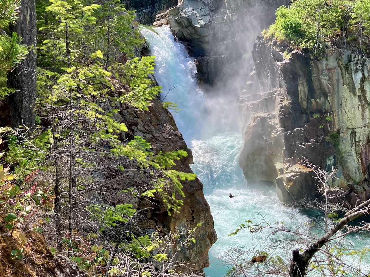
First stop was the Malaspina Galleries, a sandstone cliff carved by wind and waves. Lovely shoreline, as well.
First time to this part of Strathcona Provincial Park, Vancouver Island, I decided to tent at the biggest campground on arrival — Buttle Lake.
And was glad I did.
Easy access from Campbell River. I cycled.
Campgrounds had just opened following the COVID-19 shutdown. Their reservation system was still getting going.
I could choose any site not listed on the whiteboard.
There was one other cyclist that night — John, a cabinet maker from Vancouver — who was out-of-work at the moment from his set design job for the TV series Riverdale.
We decided to share a site and campfire.
After setting up the tent, I checked out the many short hikes accessible from camp.
Best was the Beach Access Trail
This lake has many drowned tree stumps. Very evocative.
I stumbled upon 5 campsites not shown on any map. Cool.
The Ranger informed me they were Marine Campsites, designated for those fishing and boating. BUT that they were free until June 15th.
John and I booked in for the night of June 14th.
I can hardly recall a more perfect camp.
Buttle, like most high mountain lakes, is prone to high winds due convection created by the sun heating the canyon walls during the day. Fishermen try to get off the lake by eleven.
The other big car campground in this part of the Park is called Ralph River. On paper, it’s similar. But I would recommend you camp at Buttle Lake instead, if you can.
If adventurous, you could continue to longer routes including:
climbing Big Interior mountain
continue to Mt Myra
continue to Phillips Ridge
exit via Flower Ridge
exit via Price Creek
climbing Mt Tom Taylor
Best would be to continue to Bedwell Sound, organizing a water taxi to take you to Tofino.
Good navigation needed on all those options, of course.
If I had proper snow gear I would have continued on to Cream Lake (at least) where you get views of Nine Peaks, Mt Septimus and Della Falls, highest in Canada.
I did talk to one couple who were trying to posthole their way to Cream. And they looked prepared. It would be easier later in the season.
CAUTION – A hiker died here in 2015, Anders Jason Newman. He slipped and fell from height somewhere above the lakes.
Cycled to the trailhead, walking the last 3km as Jim Mitchell Lake road was steep!
Bedwell is possibly the best maintained trail in Strathcona. So steep and (potentially) wet, numerous anti-erosion measures are necessary: wood bridges, metal bridges, boardwalk, etc.
I reached Baby Bedwell lake about 6pm. A gorgeous vista looking over to Mt. Tom Taylor.
Relaxed. Enjoyed dinner from the rocks watching the fading light.
Next morning perfect weather again. No wind.
En route to the big lake are a number of steel ladders and one chain assist. It would be very slippery when wet descending in the rain.
Wow. You arrive well above Bedwell lake with astonishing vistas.
There are tent platforms at both lakes. Personally I prefer those at Baby Bedwell over these at Bedwell.
With good weather, my return back down the same trail seemed easy to me.
Strathcona Park had just opened following the COVID-19 shutdown.
The previous day I’d tried King’s Peak with a light day pack. Didn’t get higher than 770m due to high creeks.
Learning my lesson, for Flower Ridge I brought food for up to 3 days. Full pack.
Started up about 5pm.
Like many Strathcona hikes, Flower Ridge starts with a steep climb. But less steep than most others
Not many views early on. When you do, it’s of the the Myra Falls Mine (opened 1959)
The mine is currently owned by Nyrstar and produces zinc, lead, copper, silver and gold concentrates.
Any time you are hiking a ridge, finding running water might be a problem. But my guidebook said there was one reliable creek — I never found it.
No worries. There is plenty of snow to melt. You dig to find the clean white stuff.
I set up 8:30pm at the first obvious campsite. Days are long in Canada in June.
Normally my dinners are based around instant mashed potatoes. But for this trip I went all in for instant stuffing.
I carried my 1.2 pound solar charger for the first time. Normally it stays with my bikepacking gear.
There’s no electricity in Strathcona. No mobile phone service.
I climbed higher next morning. But quickly the snow got too deep. Just like King’s Peak the previous day, I only reached perhaps 800m elevation before turning back.
The ridge is about 1200m. In those meadows I would have found more famed spring flowers.
I really need to return to Strathcona late season: August – September.
#LessonLearned
If you want to do it right, click over to MBGuiding:
Packed with hidden gems, the Old Continent is a real treat for avid hikers! Europe is the home to some of the most amazing hikes on the planet. From historical sights to natural scenery, there is something for every hiker out there.
If you are on the lookout for new exciting treks, make sure not to miss the six trails listed below!
Caucasus Mountains, Georgia: Breath-taking Trails Few Have Explored
Georgia and the Caucasus mountains are full of hidden treasures, and what’s even more exciting is that few others have been wondering these stunning places. The country is opening up to the world lately after a period of instability.
While traversing the trails, you will enjoy passing through medieval towns and villages, spotting wildlife like deer, marmot, and chamois, viewing turquoise, white, and green lakes, while surrounded by scenic peaks.
Mestia to Ushguli is one of the best trails this country has to offer. This accessible trek connects a remote mountain village of Ushguli with Mestia, the center of the Svaneti region while offering amazing natural and historical sights.
Caucasus Mountains, Telavi, Georgia
Westweg Trail, Germany: A Magical Hiking Experience
Avid hikers from all over the world are rushing to explore the ancient Black Forest. Westweg trail, the oldest and most famous long-distance hiking trail in Germany, provides a magical experience.
Green meadows, ancient forests, quiet mountain lakes, glacial valleys, panoramic rock crests, and mountains make this trail so unique.
Leading through quiet forests and over lonely plateaus, Westweg is ideal for more experienced hikers.
Before hitting the outdoors and exploring the trails, it is always advisable to learn to signal SOS and other necessary survival skills, as you may find yourself in an emergency. You’ll feel more confident, and if you are in a sticky situation, you will know exactly what to do to stay safe.
Dolomites High Route Alta Via 1: Beautiful Nature Tour of Northeastern Italy
With their unique geology and stunning rock formations, The Dolomites are trekkers’ paradise. While exploring the Alta Via 1 trail, you will see incredibly beautiful surroundings, from spiky peaks, lush forests, vast pastel meadows, to pristine alpine lakes, limestone cliffs, and even old battle sites from World War I!
You can explore steep rocky hillsides and tunnels, like famous Galleria Lagazuoi, or visit the Ladin shepherds in their villages.
With so much diversity, it is no wonder this entire picturesque area is a UNESCO World Heritage Site. And as a bonus, when you get tired or need refreshment, there are rifugios with home-cooked meals and a clean bed.
Tara Mountain, Serbia: One of the Best Kept Secrets in the Balkans
If going off the beaten path excites you, then Carpathian trails are the perfect fit. Located in Western Serbia, Tara Mountain offers incredible landscapes, especially the popular Zaovine triptych route.
Diverse topographical makeup of Dinarides with striking and deep gorges between mountain peaks makes this region particularly exquisite. Drina Gorge is one of the most beautiful ones, offering views of western Serbia and nearby Bosnia.
One of the five official lookouts, Banjska Stena, provides spectacular views of the Drina canyon, Lake Perućac, and mountain ranges. The mountain’s slopes are covered with dense forests and numerous meadows with cliffs and limestone caves.
Tara Mountain, Serbia
Alpe Adria Trail Spanning Through Austria, Slovenia, and Italy: Hiking in the Garden of Eden
The entire Alpe Adria trail usually takes over a month to hike, since it is a 466 miles long, 43-stage trail. Ever walked through the Garden of Eden? Well, here’s your chance.
A route from Carinthia’s mountain lakes to the Dolomites Mountains has been described just like that. The trail runs through non-alpine terrain most of the time, and the landscape is sure to capture your heart.
You will experience the Southern Alps’ beauty while enjoying views of sheer cliffs and vertical walls of Friuli-Venezia Giulia’portion of the Dolomites, charming villages, and breathtaking waterfalls.
Lousios Gorge Monasteries Hike in Greece: Peloponnese Peninsula Hike Into Untouched Nature
If you are looking for seldom traveled routes, start your adventure in Karytaina, and continue north to Dimitsana. Babbling streams, an abundance of wildflowers, and meadows with olive groves and cypress trees will sweep you off your feet.
The unpaved trail will get you to stunning mountaintop monasteries while walking parallel to the rushing Lousios River. The impressive and well preserved Prodromou monastery built on the cliffs of the gorge is not far from the church of Saint Athanasios.
When you get to the church, a panoramic view of the spectacular gorge and the Byzantine monasteries of Philosophou (the oldest monastery in Arcadia) emerges.
Whichever trail you choose to take, there is a fantastic adventure waiting for you! Pack your backpack, and off you go to explore the best hiking treks in Europe!
Hikerstore.co.uk is a participant in the Amazon Services LLC Associates Program, an affiliate advertising program designed to provide a means for sites to earn advertising fees by advertising and linking to Amazon.co.uk.
“As an Amazon Associate, I earn from qualifying purchases, at no extra cost to you”


 Trip report by BestHike editor Rick McCharles.