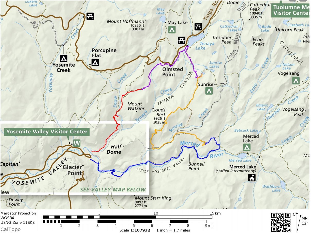
If you don’t have time to do the entire 220 mile John Muir Trail, consider this shorter alternative.
40 miles
4 days
… Along this loop you pass by the beautifulTenaya Lake, hike over Clouds Rest, take in several great views of Half Dome, and hike through Little Yosemite Valley and the Lost Valley.
The route has a peak elevation of 9,900 feet (atop Clouds Rest) and you climb roughly 9,000 vertical feet over the course of the ~40 mile trek.
Highlights include epic waterfalls, expansive views of Yosemite Valley and the surrounding granite peaks and domes, alpine lakes, grassy meadows, …
First time to this part of Strathcona Provincial Park, Vancouver Island, I decided to tent at the biggest campground on arrival — Buttle Lake.
And was glad I did.
Easy access from Campbell River. I cycled.
Campgrounds had just opened following the COVID-19 shutdown. Their reservation system was still getting going.
I could choose any site not listed on the whiteboard.
There was one other cyclist that night — John, a cabinet maker from Vancouver — who was out-of-work at the moment from his set design job for the TV series Riverdale.
We decided to share a site and campfire.
After setting up the tent, I checked out the many short hikes accessible from camp.
Best was the Beach Access Trail
This lake has many drowned tree stumps. Very evocative.
I stumbled upon 5 campsites not shown on any map. Cool.
The Ranger informed me they were Marine Campsites, designated for those fishing and boating. BUT that they were free until June 15th.
John and I booked in for the night of June 14th.
I can hardly recall a more perfect camp.
Buttle, like most high mountain lakes, is prone to high winds due convection created by the sun heating the canyon walls during the day. Fishermen try to get off the lake by eleven.
The other big car campground in this part of the Park is called Ralph River. On paper, it’s similar. But I would recommend you camp at Buttle Lake instead, if you can.
If adventurous, you could continue to longer routes including:
climbing Big Interior mountain
continue to Mt Myra
continue to Phillips Ridge
exit via Flower Ridge
exit via Price Creek
climbing Mt Tom Taylor
Best would be to continue to Bedwell Sound, organizing a water taxi to take you to Tofino.
Good navigation needed on all those options, of course.
If I had proper snow gear I would have continued on to Cream Lake (at least) where you get views of Nine Peaks, Mt Septimus and Della Falls, highest in Canada.
I did talk to one couple who were trying to posthole their way to Cream. And they looked prepared. It would be easier later in the season.
CAUTION – A hiker died here in 2015, Anders Jason Newman. He slipped and fell from height somewhere above the lakes.
Cycled to the trailhead, walking the last 3km as Jim Mitchell Lake road was steep!
Bedwell is possibly the best maintained trail in Strathcona. So steep and (potentially) wet, numerous anti-erosion measures are necessary: wood bridges, metal bridges, boardwalk, etc.
I reached Baby Bedwell lake about 6pm. A gorgeous vista looking over to Mt. Tom Taylor.
Relaxed. Enjoyed dinner from the rocks watching the fading light.
Next morning perfect weather again. No wind.
En route to the big lake are a number of steel ladders and one chain assist. It would be very slippery when wet descending in the rain.
Wow. You arrive well above Bedwell lake with astonishing vistas.
There are tent platforms at both lakes. Personally I prefer those at Baby Bedwell over these at Bedwell.
With good weather, my return back down the same trail seemed easy to me.
Strathcona Park had just opened following the COVID-19 shutdown.
The previous day I’d tried King’s Peak with a light day pack. Didn’t get higher than 770m due to high creeks.
Learning my lesson, for Flower Ridge I brought food for up to 3 days. Full pack.
Started up about 5pm.
Like many Strathcona hikes, Flower Ridge starts with a steep climb. But less steep than most others
Not many views early on. When you do, it’s of the the Myra Falls Mine (opened 1959)
The mine is currently owned by Nyrstar and produces zinc, lead, copper, silver and gold concentrates.
Any time you are hiking a ridge, finding running water might be a problem. But my guidebook said there was one reliable creek — I never found it.
No worries. There is plenty of snow to melt. You dig to find the clean white stuff.
I set up 8:30pm at the first obvious campsite. Days are long in Canada in June.
Normally my dinners are based around instant mashed potatoes. But for this trip I went all in for instant stuffing.
I carried my 1.2 pound solar charger for the first time. Normally it stays with my bikepacking gear.
There’s no electricity in Strathcona. No mobile phone service.
I climbed higher next morning. But quickly the snow got too deep. Just like King’s Peak the previous day, I only reached perhaps 800m elevation before turning back.
The ridge is about 1200m. In those meadows I would have found more famed spring flowers.
I really need to return to Strathcona late season: August – September.
#LessonLearned
If you want to do it right, click over to MBGuiding:
Hikerstore.co.uk is a participant in the Amazon Services LLC Associates Program, an affiliate advertising program designed to provide a means for sites to earn advertising fees by advertising and linking to Amazon.co.uk.
“As an Amazon Associate, I earn from qualifying purchases, at no extra cost to you”