While many tourists stick to the historic centre, the best walking is on a long green space to a complex designed by local architect Santiago Calatrava — the futuristic City of Arts and Sciences(Ciutat de les Arts i les Ciències), which contains an opera house/performing arts centre, a science museum, an IMAX cinema/planetarium, an oceanographic park and other structures such as a long covered walkway and restaurants.
It’s impressive.
Cityscape of Valencia. Turia park. Aerial view
Usually called Turia Garden, the park is officially 9km long. But expect your mileage to be quite a bit longer. I was on it at least 5 hours with side trips.
To start, I caught the subway to the Zoo on the far left of this map.
… its existence was not made known to the world until after an expedition made in 2002 by a German, Stefan Ziemendorff, with a group of Peruvian explorers. …
Citing various encyclopedias, reference books, and webpages accessible through Google, Gocta Cataracts are unofficially listed as the world’s fifth-tallest, after adding Ramnefjellsfossen (Norway) and Mongefossen (Norway).
Furthermore, The World Waterfall Database ranks Gocta as the 16th tallest. …
Tourists can now hike the trails by foot or horse to the misty base of the waterfall. The nearby town of Chachapoyas is located at an altitude of 2,235 meters (7,333 feet).
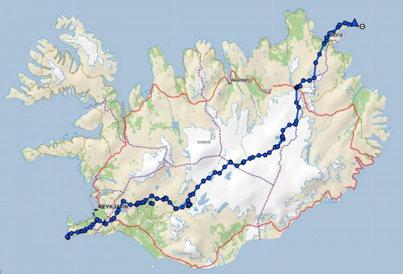
Iðunn Bragadóttir and her 20-year-old daughter, Þóra Dagný Stefánsdóttir, have spent 32 days traversing Iceland. The duo started on the Reykjanes peninsula and hiked diagonally, southwest to northeast, across the country to Langanes Point.
The 786km route is one of the longest possible ways to traverse Iceland. …
Yoho Lake was the site of the original Alpine Club of Canada camp in 1906.
Early alpinists climbed Mt Wapta (south) and Michaels Peak (north).
Mt Wapta
Returning from our Twin Falls hike, we resupplied at the vehicles parked at the Takakkaw Falls trailhead.
Then started with great views over to Takakkaw , the second highest Falls in Canada.
One of our group forgot his sunglasses at the lookout.
ET and I asked some hikers going the other direction to see if they could find them. And it worked! We found them on ET’s vehicle 2 days later.
We climbed steadily up to the lake on a route that many switchbacks.
More wildflowers here than on the Twin Falls side.
You catch a glimpse en route of Hidden Lake.
Here’s a first look at Yoho lake.
Yoho lake is deep emerald green, more so than Emerald lake.
You’d have to be CRAZY to swim.
Warren set up a cook tarp to protect from sun and rain.
It’s a peaceful campground.
Next morning we had one deer hang around the tents. I assume he was salt deprived, looking for urine.
We took a day hike to look down on to Emerald lake.
There are some impressive waterfalls en route.
Warren and I decided to extend the walk and circumambulate Emerald lake. (Actually, we had originally planned to return via Burgess Pass trail — but it seemed to be unsigned and closed in 2020.). So we walked around Emerald lake and back the way we came.
The only difficult section was about a half hour of flooded alluvial plain.
Once back in camp we found our group had decided to hike out a day early. Forecast was for big storm.
Rather than camp at the Takakkaw Falls campground, we instead drove to Banff and enjoyed a dry night at the Hidden Ridge resort.
On July 1, 2020 I cycle toured Gabriola Island, the first time I’d been back to the island since I was a kid on family summer vacation.
Gabriola is about 14 kilometres (9 mi) long by 4.2 kilometres (2.6 mi) wide, about the same land mass as Bermuda.
I caught the ferry over from Nanaimo in the early evening.
Next morning, while celebrating Canada Day, I was reminded that descendants of the original inhabitants are still there — the Snuneymuxw, a First Nation of the Coast Salish People.
Sobering.
First stop was the Malaspina Galleries, a sandstone cliff carved by wind and waves. Lovely shoreline, as well.
Hikerstore.co.uk is a participant in the Amazon Services LLC Associates Program, an affiliate advertising program designed to provide a means for sites to earn advertising fees by advertising and linking to Amazon.co.uk.
“As an Amazon Associate, I earn from qualifying purchases, at no extra cost to you”